
There are some drives that end up being more than just a route on the map — they’re a story, a feeling, a rhythm. For me, the Kancamagus Highway was exactly that kind of drive.
I started early one summer morning in Lincoln, New Hampshire, camera gear packed, coffee in hand, ready to take on one of New England’s most famous scenic roads. The Kancamagus, or “The Kanc” as everyone calls it, winds for about 34.5 miles through the heart of the White Mountain National Forest, connecting Lincoln on the west with Conway on the east. I had my Leica Q3 and Fuji X-T5 with me — my favorite combo for travel photography. You can see how I set them up in my Travel Photography Gear Guide.
The winding turns reminded me of the Blue Ridge Parkway, another mountain drive that feels timeless in its own way.
People often talk about driving it in autumn, when the trees explode into fiery reds and golds — and I can see why. Fall is legendary here. But my trip happened in summer, when the air smelled of pine and river water, the greens were lush and endless, and the mountains felt alive in a different way.
If you’re exploring more of New England’s hidden routes, check out my full Northeast Region Travel Guide — it includes Vermont, Maine, and other scenic drives just like this one.”
The Road Ahead
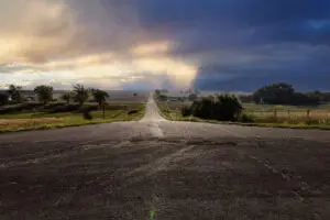
Before setting out, I topped off the gas tank and packed snacks — there are no gas stations or restaurants once you’re on the Kanc. Just trees, sky, and the hum of tires on smooth pavement.
Even though it’s only 34.5 miles from end to end, it’s not a road to rush. I spent most of the day stopping at trailheads, overlooks, and waterfalls — and by the time I reached Conway that evening, my memory card was full and my heart was even fuller.
(Here’s a map of the route, if you want to follow it for your own trip!)
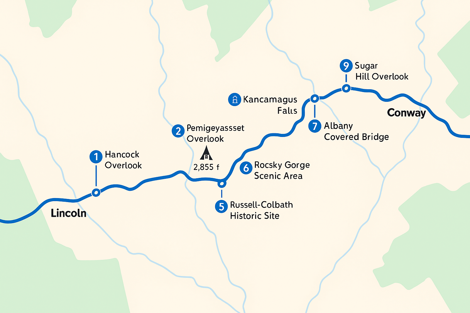
First Stop: The Hancock Overlook
Not long after leaving Lincoln, the road began to climb into the White Mountains, twisting through thick forest before breaking open into wide, breathtaking views.
The Hancock Overlook is one of the first major viewpoints heading east — a sweeping panorama of ridgelines that seem to stretch forever. I stepped out into warm morning light, the air still cool at elevation, and framed the valley below through my Leica’s viewfinder.
A few more curves up the road, another pullout appeared — the Pemigewasset Overlook — offering a slightly different angle of the same mountain magic. I stayed longer than planned, just watching clouds drift across the peaks.
The scale of the White Mountains brought back memories of Grand Teton National Park, where mountains dominate the skyline just as beautifully.
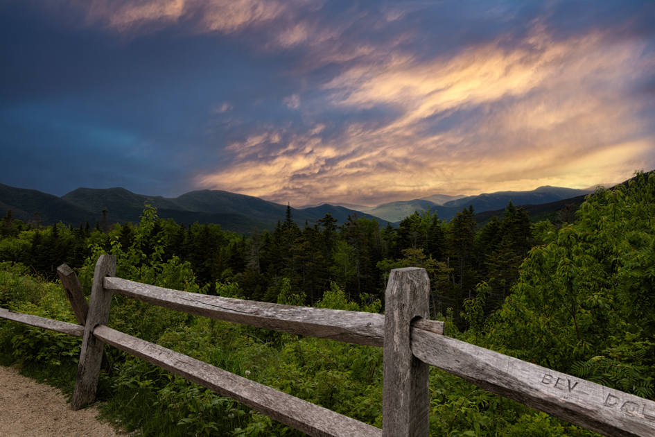
Kancamagus Pass and the High Country
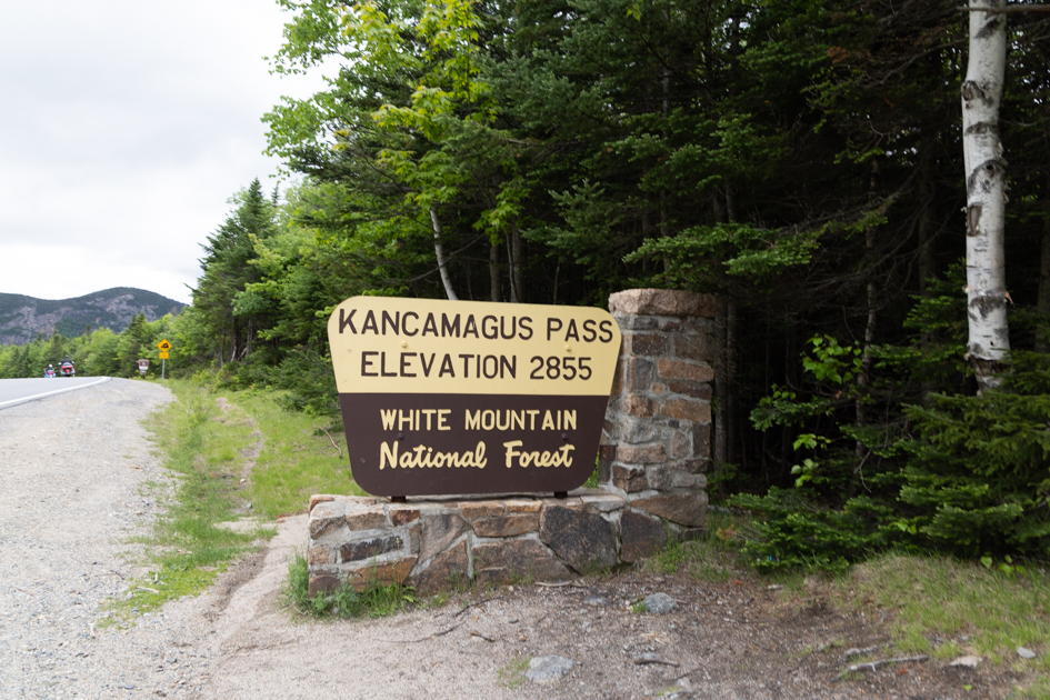
As the road crested Kancamagus Pass (elevation 2,855 feet), I felt that mix of excitement and quiet that always hits me in mountain country. Pines thinned near the summit, and the horizon opened into a rolling sea of green.
Even in summer, the temperature dropped noticeably — one of those subtle reminders of how quickly elevation changes the feel of a place. I lingered at a small turnout, photographing the layered blues of distant ridges under a hazy sky.
The White Mountains have a way of humbling you — they remind you how small you are and how lucky you are to see them.
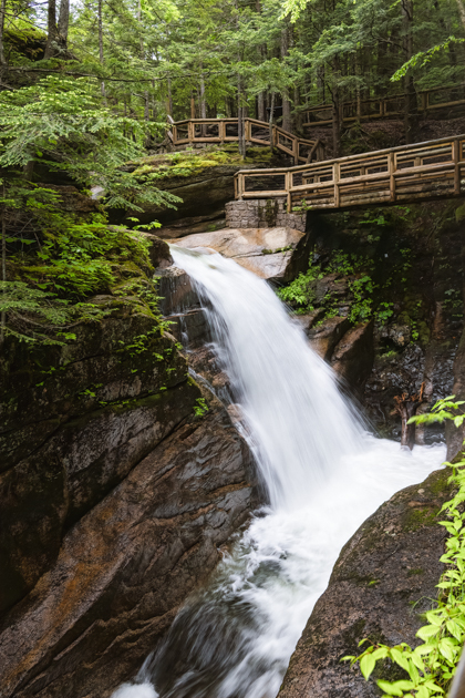
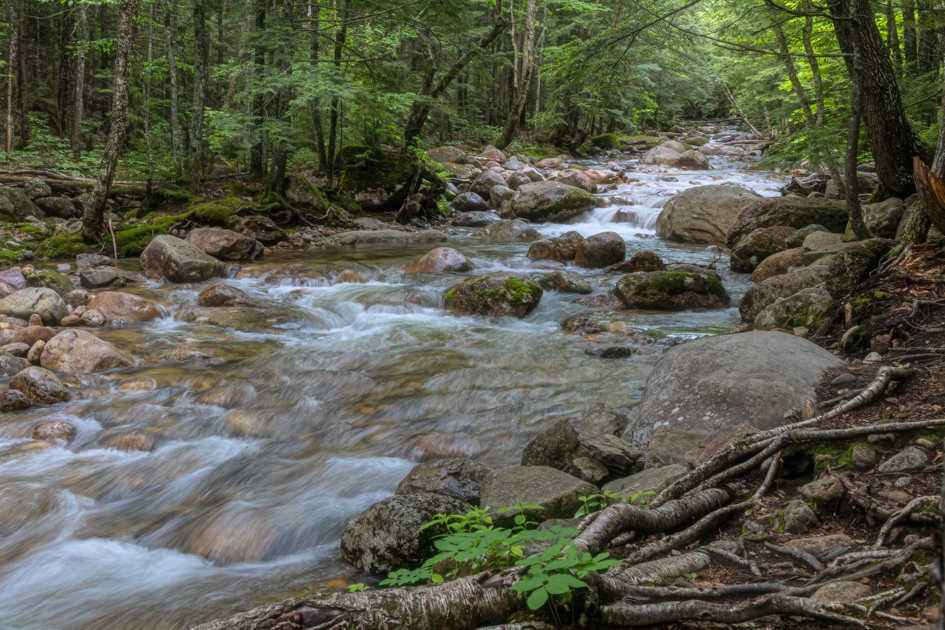
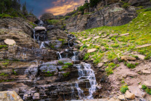
Sabbaday Falls: My Favorite Stop of the Day
About halfway along the Kanc, a sign for Sabbaday Falls caught my eye — and I’m so glad it did. The short trail through the forest felt like stepping into a green tunnel, with sunlight filtering down in ribbons.
Within minutes, I could hear the waterfall — that low, steady rush that always draws me in. Wooden steps and railings led up to a narrow gorge where the water cascades through a series of pools.
I took both photos and a short video here — the sound of rushing water echoing softly through mossy rock walls. It was one of those perfect summer moments: cool shade, soft light, and the kind of peace you can feel in your chest.
If you’d like tips for capturing light in places like this, read my post on Mastering Travel Photography — it covers composition, aperture, and exposure techniques I use on the road.” For another New England waterfall adventure, try the short hike to Eternal Flame Falls in New York where a natural flame glows behind the water.
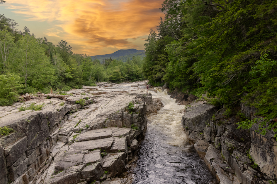
Rocky Gorge: Power and Calm
A few miles beyond Sabbaday Falls, the Rocky Gorge Scenic Area appears almost without warning. The Swift River cuts through a narrow granite channel here, roaring with surprising force.
A wooden bridge crosses above the gorge, offering a perfect vantage point for photography — especially when sunlight hits the mist. It’s one of those spots that’s beautiful but deceptively strong, so swimming isn’t allowed. Still, it’s a place to stand still and feel the raw energy of moving water.
There’s a quiet pond just beyond the gorge, where the river slows — a perfect counterbalance to the power you’ve just witnessed. I sat there for a while before continuing east.
Russell-Colbath House: Echoes of the Past
Not far from the gorge, I stopped at the Russell-Colbath Historic Site — a small, restored homestead built in 1831. It’s hard to imagine families living in such isolation, but this house once stood in a small farming and logging community that lined the Swift River Valley.
The old barns, stone walls, and weathered wood make it a rewarding photography stop, especially if you love the texture of history. The site is managed by the Forest Service and occasionally open for tours during summer.
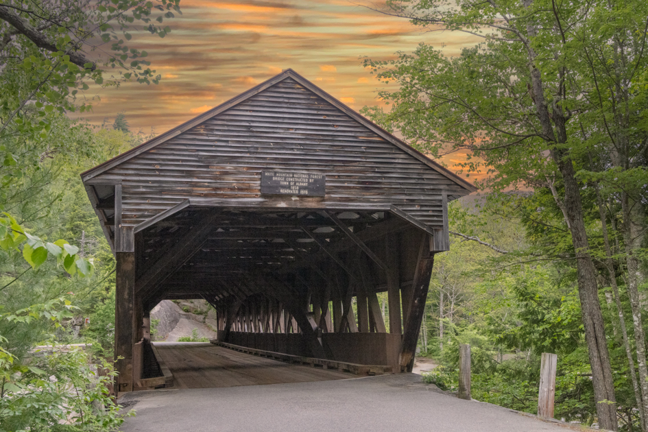
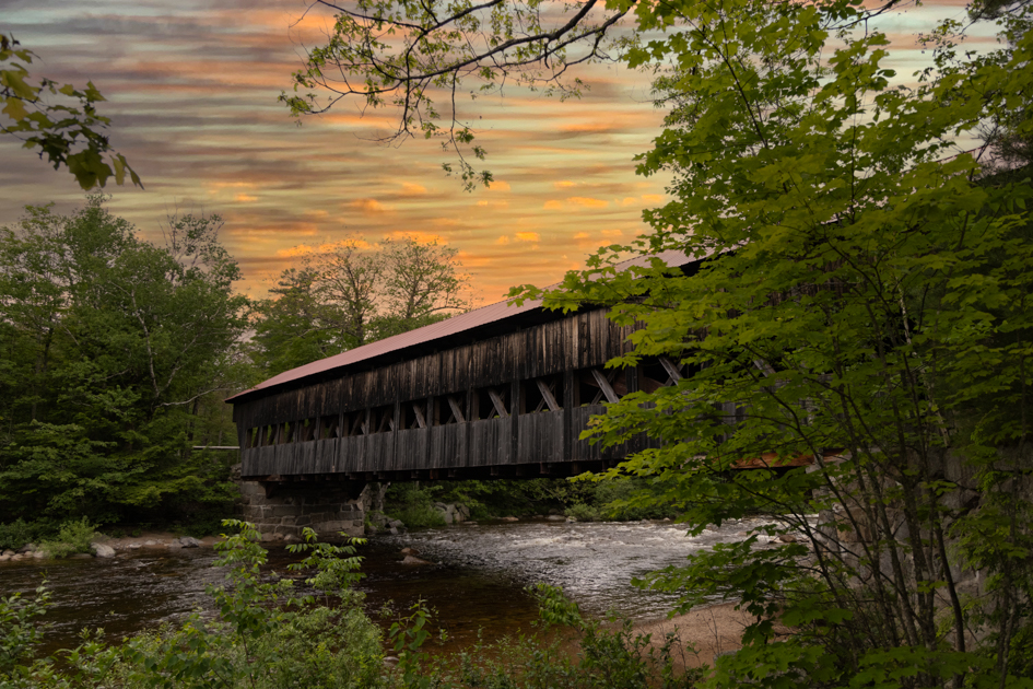
Albany Covered Bridge: A Classic Finish
As the road began to level out and the forest opened toward Conway, I made one last stop — the Albany Covered Bridge. Spanning 120 feet across the Swift River, it’s one of those quintessential New England scenes that feels straight out of a postcard.
Late afternoon light was spilling across the water when I arrived. I framed a few shots of the bridge’s reflection and stood quietly for a while, listening to the river ripple under the old timbers.
It felt like the perfect place to end the day — one more photograph, one more quiet moment before rejoining the rest of the world.
A Road Steeped in History
The Kancamagus Highway might be a scenic drive today, but its story goes back centuries. The name comes from Kancamagus, the last sagamore (chief) of the Pennacook Confederacy, who lived in the late 1600s.
He sought peace with English settlers, but after years of conflict and betrayal, his people moved north toward Canada. The modern highway was finally completed in 1959 — connecting two older roads built by neighboring towns — and paved in the 1960s.
When you drive it, you’re not just following a scenic byway — you’re traveling a path layered with stories of both the land and the people who lived here long before the first car rolled through. This drive could easily fit into a longer trip. For for information on how we plan, see a 30-Day USA Road Trip Guide: How We Explore America’s Back Roads.
Seasons on the Kancamagus: Fall or Summer?
Most travelers plan their Kancamagus drive for autumn, when the White Mountains put on their world-famous foliage show. It’s a kaleidoscope of color — golden birch, deep red maple, orange sugar oaks.
But my summer visit had its own charm. The greens were endless and alive, the rivers high, the air warm but crisp at elevation. There’s a calmness to the Kanc in summer — fewer crowds, more stillness, and time to simply breathe it all in.
One day, I’ll come back in October for the full fiery spectacle. But this trip, with the light slanting through tall pines and the sound of rivers always nearby, reminded me that every season here tells its own story.
Final Thoughts
By the time I rolled into Conway that evening, the sky was soft pink and gold. My memory cards were full of waterfalls, ridgelines, bridges, and quiet corners of the forest.
The Kancamagus Highway isn’t long — but it lingers with you. It’s one of those drives where every stop feels like a new page in a story you never want to end.
For travelers, it’s peaceful.
And for photographers, it’s paradise.
For me, it was both.
Standing by the Swift River that afternoon, I realized that beauty doesn’t always announce itself — sometimes it just waits for you to slow down long enough to see it. The same feeling follows me wherever I go, whether I’m deep in the White Mountains or back on the trails near home. If you love that sense of discovery close to where you live, you might enjoy my post Finding the Wild Close to Home, where I share how even familiar places can surprise you when you look with a photographer’s eye. And if you are in the area and want to explore more Northeast USA destinations, my Northeast Region Travel Guide has some suggestions for off-the-beaten-path destinations.
For more inspiration on routes like this, visit my cornerstone post Scenic Drives and Road Trips Across America.
✉️ Want More Hidden Drives and Scenic Routes?
Sign up for my newsletter and follow my next off-the-beaten-path journeys through America’s back roads.
